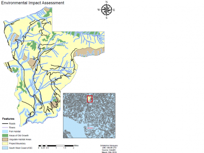
Environmental Impact Assessment
Introduction
The Northland Properties and Aquilini Investment Group of Vancouver are planning on
constructing a four-season resort 80 km north of Vancouver and 45 km south of Whistler.
The area of land that is being investigated for this project includes fishery habitat, old
growth forest, and ungulate winter range.
Results
- The area within the project boundary that is covered by the ungulate winter range is
estimated at around 8%.
- 32% of land has an elevation lower than 600m, which will not receive any snow.
- 7% of the project land is covered by an old growth forest.
- 28% of the land is covered by fish-bearing streams.
Discussion
The total project area that is protected is an estimated 38 percent, which is not a significant
impact on British Columbia's wildlife. The 32% of land that falls below the 600m contour will
not receive any snow, this can be used as space that is dedicated for spring and summer
activity or can also be developed for residence. This location is not in any high-risk forest fire
zone, past fires in these areas were all caused by human activity, therefore the risk of
natural forest fires is not imminent. This resort will also contribute to the economy, providing
2500 jobs during the 20 year construction period. This resort is also closer to Vancouver
than Whistler, providing more travel options.
Errors
There is a possibility that the data does not have positional accuracy and precision. The age
of the data needs to be updated as rivers are dynamic and ever-changing, animals can
change their migration routes. There only 3 categories that are considered in these analyses,
the ungulate range, fish habitat, and old growth. There are several other factors that can also
be considered, such as endangered plant species, other animal ranges such as cougars,
black bears, etc.
Conclusion
After analyzing the data, 62% of the land is unprotected and can be used for development.
We are only looking at 3 categories to classify as the protected zone, applicable land may
decrease if more categories are considered. This project has the potential to improve BC’s
economy. With careful consideration for the natural reserves and building around the
protected areas, this can be a successful investment.
Appendix
Environmental Assessment Map1: EIA
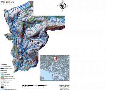
3D Hillshade Map: EIA3D
This lab we learned how to calculate areas of polygons, reclassify a DEM based on elevation and convert it to a polygon. merge polygons, Build a multi-field query using the select by attribute tool, and create a buffer of varying widths.